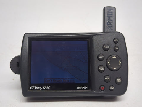
Garmin GPSMAP 176C

Best versatile navigation tool for outdoor enthusiasts and marine hobbyists.
This rugged, multi-purpose navigator brings reliable, high-contrast mapping to the water or the road. It is a classic workhorse for those who value precise, WAAS-enabled positioning, though you will need to source your own cables and power supply to get it running.
$149.95
at
Second Wind Sales
Who it's for
- Boaters operating in harsh, wet, or demanding weather conditions
- Navigators needing clear visual contrast for easier map reading
- Users requiring reliable signal strength in enclosed or obstructed spaces
Who should skip it
- Modern sailors requiring fast, affordable, and easily updated map data
- Captains needing quick, responsive map panning during active navigation
- Tech-focused users wanting seamless integration with contemporary marine electronics
Performance breakdown
Navigation Accuracy
WAAS-enabled 12-channel receiver provides reliable positioning for open water and roads.
Display Clarity
The 16-color TFT screen shows basic data but lacks modern resolution.
Cartography Versatility
Robust support for BlueChart and MapSource data expands your navigational reach.
Setup Convenience
Requires additional cables and batteries, complicating the initial installation process.
Build Durability
Rugged design holds up well across automotive, marine, and RV environments.
Interface Simplicity
Straightforward button layout makes essential navigation tasks easy to manage.
Key Specs
Display Size
3.8 inches
Display Resolution
320 x 240 pixels
GPS Receiver
12 parallel channel, WAAS-enabled
Cartography Support
BlueChart marine cartography chips
Antenna Type
Built-in
Display Type
TFT, 16-Color
Card Slot
Miniature-size chip (for BlueChart)
Condition
Sold AS-IS (No cables or battery included)
Preloaded Charts
Worldwide Basemap
Mounting Type
Bracket Mount
Know before you buy
Still have a question?
Ask Metto anything about the Garmin GPSMAP 176C before you decide.