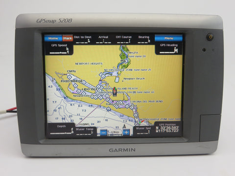
Garmin GPSMAP 5208

Best marine chartplotter for serious boaters navigating open waters.
This chartplotter turns complex navigation into a simple, tactile experience with its intuitive touchscreen interface. While it lacks the flashy, high-resolution displays of modern glass-cockpit systems, it remains a workhorse for those who prioritize rugged reliability and seamless integration over cutting-edge aesthetics.
$699.95
at
Second Wind Sales
Who it's for
- Captains needing clear visibility in direct sunlight
- Skippers building a fully integrated helm station
- Boaters prioritizing long-term hardware reliability
Who should skip it
- Users requiring fast, fluid map interaction
- Tech-focused sailors wanting modern software features
- Navigators needing the latest high-resolution chart detail
Performance breakdown
Interface Responsiveness
Touchscreen navigation remains intuitive even in challenging marine environments.
Connectivity Versatility
Dual NMEA support ensures seamless integration with your existing vessel electronics.
Display Clarity
XGA resolution provides sharp visuals, though modern screens offer higher pixel density.
Durability Rating
IPX7 waterproofing guarantees reliable performance against harsh saltwater exposure.
Navigation Capacity
Waypoint and route limits are sufficient for standard coastal cruising needs.
System Expandability
Robust radar and sonar support turns this unit into a command center.
Key Specs
Display Size
8.4 inches
Display Resolution
640 x 480 pixels
Dimensions
10.1" W x 6.8" H x 4.2" D
Waterproof Rating
IPX7
Waypoint Capacity
1,500
Navigation Routes Capacity
20
Network Compatibility
NMEA 0183 and NMEA 2000
Card Slot
1 SD Card
Preloaded Charts
Worldwide Basemap
Interface Control
Touchscreen
Know before you buy
Still have a question?
Ask Metto anything about the Garmin GPSMAP 5208 before you decide.